Where Is Mount Everest Located in the World? (Geographical Location Explained in Detail)
Mount Everest is located in South Asia, on the continent of Asia, within the massive Himalayan mountain range, which stretches across five countries—India, Nepal, Bhutan, China (Tibet), and Pakistan. More specifically, Mount Everest stands directly on the international border between Nepal and the Tibet Autonomous Region of China. This means that no single country fully owns Mount Everest; instead, the summit itself is shared by both Nepal and China.
From a global mapping perspective, Mount Everest lies at approximately 27.9881° North latitude and 86.9250° East longitude. These coordinates place it in a remote high-altitude region where the Earth’s crust was forced upward over millions of years due to the collision between the Indian tectonic plate and the Eurasian plate. This geological collision is what created the entire Himalayan range and made Everest the highest point on Earth.
On the Nepal side, Mount Everest is located within the famous Sagarmatha National Park, a protected UNESCO World Heritage Site known for its extreme alpine terrain, glaciers, deep valleys, and rare wildlife. This park lies in the Solukhumbu District, which is home to the Sherpa people, the legendary mountain guides who have helped climbers reach Everest for decades. On the Tibet side, Everest lies in Tingri County, part of the vast and elevated Tibetan Plateau, often called the “Roof of the World.”
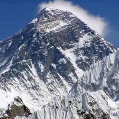
When people ask, “Where is Mount Everest located on the world map?”, the simplest answer is that it sits along the curved Himalayan arc between Nepal and China, north of India and south of Tibet. Despite being located in Asia, Mount Everest is so massive and isolated that it feels like a world of its own, rising far above every other peak around it. Its location also places it in one of the harshest and most extreme natural environments on Earth, where oxygen levels are dangerously low, temperatures can fall below –60°C, and storms can appear without warning.
Is Mount Everest in Nepal or China? Understanding the Border, Ownership, and Political Geography

One of the most common questions in the world is whether Mount Everest is in Nepal or China. The correct answer is: Mount Everest is in both countries. The official border between Nepal and China runs directly across the summit of Mount Everest, splitting the peak between the two nations. This makes Everest one of the most famous shared natural landmarks on Earth.
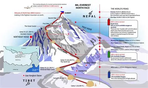
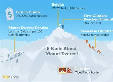
The southern face of Mount Everest belongs to Nepal, and this side is where the most popular trekking routes, villages, and climbing expeditions are located. The famous South Base Camp, which sits at an elevation of about 5,364 meters (17,598 feet), is located in Nepal. This base camp is reached by trekking through the Khumbu Valley after flying into the small mountain airstrip at Lukla Airport. Most commercial climbing expeditions take the Nepal route because it is more established, has better infrastructure, and is supported by the Sherpa community.
The northern face of Mount Everest lies in Tibet, China, and includes the North Base Camp, which sits at about 5,150 meters (16,900 feet). This side of Everest is accessed by road from cities such as Lhasa and Shigatse, making it easier to reach by vehicle compared to the long trek on the Nepal side. However, this route is often more strictly regulated by Chinese authorities, with limited climbing permits and seasonal restrictions.
Politically, Nepal and China both recognize the summit as a shared natural border point. In 2020, both countries jointly announced the official height of Mount Everest as 8,848.86 meters (29,031.7 feet), ending decades of debate over its true measurement. This cooperation also symbolized peaceful shared ownership of the world’s tallest mountain.
From a cultural perspective, Mount Everest holds deep spiritual meaning on both sides of the border. In Nepal, it is called Sagarmatha, which means “Goddess of the Sky” in Sanskrit-based Nepali language. In Tibet, it is known as Chomolungma, meaning “Goddess Mother of the World.” These names reflect how the mountain is not just a physical object, but a sacred presence in local belief systems.
So when people ask, “Which country owns Mount Everest?”, the most accurate answer is that both Nepal and China share Mount Everest, politically, geographically, and culturally.
Where Is Mount Everest for Travelers, Trekkers, and Climbers? (Access Routes, Base Camps, and Surrounding Regions)
For travelers and adventure lovers, “where is Mount Everest” often means where you actually go to see it or climb it. The most popular and accessible route to Mount Everest is through Nepal, which has become the world’s most famous destination for high-altitude trekking and mountaineering.
Most journeys toward Mount Everest begin in Kathmandu, the capital city of Nepal. From there, travelers take a short but thrilling flight to Lukla, a small mountain town perched on a steep hillside with one of the world’s most dangerous airports. From Lukla, trekkers walk for about 8 to 12 days through the Khumbu Valley to reach Everest Base Camp. Along the way, they pass through famous villages such as Namche Bazaar, Tengboche, Dingboche, and Lobuche, surrounded by towering Himalayan peaks, prayer flags, glaciers, and ancient monasteries.
The Nepal route to Everest gives visitors a close look at Sherpa culture, Buddhist traditions, suspension bridges, and dramatic mountain landscapes. Even people who never plan to climb Everest still visit the base camp simply to witness the mountain with their own eyes. For many travelers, reaching Everest Base Camp is considered one of the greatest trekking achievements in the world.
On the Chinese side, Mount Everest is approached via long high-altitude roads across the Tibetan Plateau. Travelers typically start from Lhasa, travel west to Shigatse, and continue by road toward Rongbuk Monastery, the highest monastery in the world. Near this monastery lies the North Base Camp of Everest, which offers one of the closest non-trekking views of the mountain. This side of Everest is colder, windier, and more isolated, but it offers stunning panoramic views of Everest’s north face.
For climbers, Everest has two main ascent routes:
- The Southeast Ridge Route from Nepal (the most commonly used path).
- The Northeast Ridge Route from Tibet (more technical and politically restricted).
Both routes are extremely dangerous and require months of preparation, proper permits, professional guides, and physical conditioning. Despite modern equipment, Mount Everest still claims lives every year due to avalanches, altitude sickness, storms, and extreme exhaustion.
In practical travel terms, Mount Everest is not a single tourist spot but a massive high-altitude region spread across two countries, reachable only through careful planning, long journeys, and respect for nature.
Why Is Mount Everest Located Where It Is? (Geology, Height, and Natural Formation of the Himalayas)
The location of Mount Everest is not random; it is the result of one of the most powerful geological events in Earth’s history. Around 50 million years ago, the Indian tectonic plate began crashing into the Eurasian plate. Instead of sliding under one another, the plates compressed and folded, slowly forcing rock upward into massive mountain ranges. This ongoing collision created the entire Himalayan mountain system, including Mount Everest.
Even today, Mount Everest is still growing. Scientists estimate that Everest rises by about 4 millimeters per year, although earthquakes can sometimes reduce its height slightly. The 2015 Nepal earthquake, for example, shifted parts of the Himalayas and led to renewed surveys of Everest’s height.
Mount Everest’s exact position at the edge of the Tibetan Plateau means it experiences some of the most extreme environmental conditions on Earth. The air at the summit contains only about one-third the oxygen available at sea level, making survival without supplemental oxygen nearly impossible. Temperatures at the top can drop below –60°C, and winds can exceed 200 km/h (125 mph) during powerful jet stream conditions.
Despite these extreme conditions, the location of Mount Everest has also allowed unique ecosystems to survive at lower elevations. The forests and valleys below Everest support rare animals such as:
- Snow leopards
- Red pandas
- Himalayan tahr
- Musk deer
These ecosystems exist only because of the altitude gradients created by Everest’s towering presence.
The mountain’s unique position also makes it highly visible from great distances on clear days, especially from nearby peaks like Kala Patthar, which offers one of the most famous views of Everest from the Nepal side.
Final Conclusion
Understanding where Mount Everest is located is not just about pinpointing a spot on a map. It means understanding its position between Nepal and China, its place within the Himalayan mountain system, its deep cultural significance, and its extreme natural environment. Mount Everest stands as a powerful symbol of Earth’s geological strength, human ambition, and the limits of physical endurance. Whether viewed from the valleys of Nepal or the plateaus of Tibet, Everest remains the ultimate landmark of our planet. Articles like this on Empire Magazines aim to make such powerful locations easier to understand for readers who seek knowledge along with inspiration.
Frequently Asked Questions (FAQs) – Where Is Mount Everest
1. Where is Mount Everest located exactly?
Mount Everest is located in the Himalayan mountain range in Asia, directly on the border between Nepal and the Tibet Autonomous Region of China.
2. Is Mount Everest in Nepal or China?
Mount Everest is in both Nepal and China. The southern side lies in Nepal, while the northern side lies in Tibet (China). The summit itself is shared by both countries.
3. In which continent is Mount Everest located?
Mount Everest is located on the continent of Asia.
4. What are the exact coordinates of Mount Everest?
The exact coordinates of Mount Everest are approximately:
27.9881° North latitude and 86.9250° East longitude.
5. Which mountain range is Mount Everest part of?
Mount Everest is part of the Himalayas, specifically the Mahalangur Himal sub-range.
6. Where is Mount Everest Base Camp located?
There are two base camps:
- South Base Camp is in Nepal (5,364 meters)
- North Base Camp is in Tibet, China (5,150 meters)
7. What is Mount Everest called in Nepal and Tibet?
- In Nepal, Mount Everest is called Sagarmatha
- In Tibet, it is called Chomolungma.
8. Why is Mount Everest so high?
Mount Everest is so high because of the collision between the Indian and Eurasian tectonic plates, which pushed the Earth’s crust upward over millions of years.
9. Can tourists visit Mount Everest without climbing it?
Yes, tourists can visit Everest Base Camp in Nepal by trekking and North Base Camp in Tibet by road without climbing the mountain.
10. Which country is best for seeing Mount Everest?
Nepal is considered the best country for viewing Mount Everest up close because of its popular trekking routes, clear viewpoints, and Sherpa culture.